 |
 |
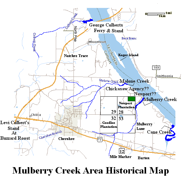
The land where Mulberry Greens Estate is located (Section 28, Twn 3, Rge 13 - See Map Below) has a rich and interesting history. Much of the history occured before written records were kept.
The evidence of human use of the area comes from stone tools, pottery, burials and other archaeological materials recovered by researchers. Several archeaological projects have been conducted in the area. The Mullberry creek area was the site of a study done by TVA before they impounded Pickwick Reservoir. Stanfiled-Worley Shelter, eight miles south, was excavated by The University of Alabama in 1961 and recovered remains that have been dated to 9,640 years ago. These studies, as well as artifacts found on Mulberry Greens, indicate that Aboriginal Americans lived or visited here in all five major aboriginal stages, the Paleoindian Stage, Archaic Stage, Woodland, and Mississipian and the European Stage.
It is still possible to find evidence of the Indian habitation of the area. There are poplar arrowhead hunting areas in the fields along the river including the fields on Mulberry Green. A significant "shell midden mound", created by Indians, is still visible at the mouth of Mulberry Creek during low reservoir conditions. Mulberry Creek enters the Tennessee River about 1/4 mile East of Mulberry Greens Estate.
Indian presence in the area was still significant when Alabama became a state in 1819. By that time whites were already settled in the Florence area and in "York City" (Near present day Muscle Shoals and Sheffield). However, the area South of the Tennessee River and West of Cane Creek (near hwy 247) was still part of Chickasaw Territory and whites were not allowed to establish residences. George Colbert, who the county is named for, operated a ferry 5 miles down stream on the Tennessee River which provided Natchez Trace travelers a way of crossing the river. In the treaty of 1832 the land was granted to "Indians with White Blood".
While the area was not open for settlement during the Chickasaw Period, a trading post was permitted in the Indian territory for conducting business with the Indians. The first agent to be appointed in the Chickasaw Nation was B.F. Smith, appointed in 1825. He located the Chickasaw Agency between Malone Creek and Mulberry Creek on the Tennessee River, three miles east of Georgetown. The exact location of the Agency is currently unknown but documents describe it as "on the bluff overlooking the Tennessee River". Smith was replaced in 1829 by Benjamin F. Reynolds, a personal friend of President Andrew Jackson.
Section 28 and the area West of Cane Creek did not become available for white settlement until the Indians were forcibly removed during the "Trail of Tears" between 1832 and 1838. A river landing and town were established in the 1830s on the Tennessee River just down stream from the point where Mulberry Creek enters the river and was named "Newport Landing". The exact location of the old town is unknown but the port and wharf are most certainly flooded by Pickwick Reservoir.
Samuel Oates, a wealthy planter from Lawrence County, bought 1207 acres of land including all of Section 28, land along the river, and other tracts of land in the area some time before 1840. He established his home in section 28 and named it "Newport Plantation". The Manor house was located 1/2 mile due south of Mulberry Greens just off Mulberry Lane. Little evidence of the old plantation home is visible today, however the family cemetery still exists on land TVA acquired to construct Pickwick Reservoir. The cemetery is in disrepair and is not maintained.
Samuel Oates died in 1854 leaving Newport Plantation to his son, David C. Oates. David was appointed the first postmaster in the Cherokee area in 1854 and established the Post Office on "Newport Road", most likely what today is referred to as "Mulberry Lane". David operated the plantation until the late 1870's when financial difficulties forced him to sell. A. J. Parker purchased Section 28 in 1878 and the area was still known as the "Parker Place" into the 20th century. Section 28 was divided in the 1900's and several prominent farming families of the area owned parts of it. Sir names such as Smith, Reeder, Thomason, Chambers, Sockwell, Reid and Jeffrey can be found on deeds as the land changed hands.
Acknowledgment: Appreciation goes to Lewis C. Gibbs, Jr., Edward F. Vengrouskie and Jimmie McWilliams for historical information included on this page.
 |